


Just before the country enters the last week of monsoon 2022, rains drenched most parts of North India in the past week.
Major cities have come to standstill due to waterlogging caused by very heavy rains. It’s complete chaos in smaller cities as well, multiple cities in Haryana, Punjab, West Uttar Pradesh, East Rajasthan broke all-time records for rainfall in the month of September.
Record-breaking rains in many parts of Haryana
Narnaul in Mahendragarh district recorded 196.0mm rainfall ending 8:30 am on 25 September. It is the highest ever single rainfall recorded during the month of September breaking the previous record of 165.0mm on 28 September 1996.
Till 8:30AM on Sunday morning Rohtak recorded 165mm rainfall in the span of just 9 hours breaking its single day highest ever September rainfall record of 158.9mm from 11th September, 2009.
Also city observed 309mm rainfall in the last 3 days this is the highest rains in the month of September after 1995 when it experienced 540mm of rains in the span of total 6 days leading to major flood outbreak, considering the 3 days rain accumulation flash flood like conditions have been observed especially in the last 36 hours when the rain intensity was on peak.
Bhuna in Fatehabad district experienced 377 mm rainfall in the span of the last 24 hours. Almost the annual rains of the station have occurred in a single day.
Rainfall in some other stations of the district:
Kulan — 268mm
Ratia — 207mm
Fatehabad city — 140mm
Various parts of Gurgaon were also submerged amid incessant heavy rains. The millennium city experienced 242mm rainfall in the past three days – the second highest September rains in the last decade.
Massive rainfall in a short time also damaged standing Kharif crops in the state. Bajra and rice are majorly affected as fields are submerged in water.
Delhi’s base observatory Safdarjung observed 18.6mm rainfall in the past 24 hours ending 8:30am on 25 September, the monthly total having reached 164.5mm against the normal of 118.2mm the departure from normal stands at +39 per cent for the month.
Amid good rain in the capital the seasonal rainfall at Safdarjung crossed 500mm rainfall mark at 516.9mm since 1 June, still, a shortfall of -19 per cent is there as normally it records 635.1mm rains in this period.

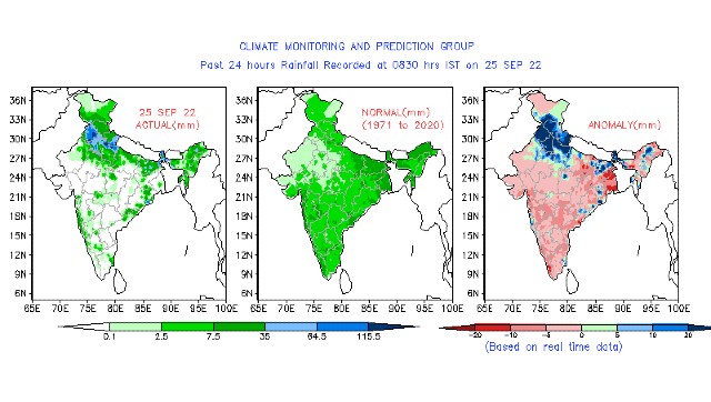
Rainfall in the last 24 hours ending 8:30 am on 25 September remained highly above normal and restricted to northern states of the country
The credits for outstanding rains at the end of the season goes to the low-pressure area travelling from the Bay of Bengal across Central India reached North india towards the end of the week and became stationary around West Uttar Pradesh and Adjoining south Haryana for 3 days in a row just before re curving towards Uttarakhand due to upcoming Western Disturbance trough.
Over the past week weather conditions were largely dry across South India in absence of any major weather system, Central and eastern parts of the country received near normal rains.
As per IMD data pan-India Monsoon rains have crossed 900mm mark on Sunday
• Since 1st June India as a whole recorded a total of 909.3mm rainfall against the average of 848.5mm, a departure from normal stands at +7%, departure continue to stay similar to last Saturday’s number of +7% as rains were balanced across the country as North received larger chunk in the week.
Subdivision wise seasonal rainfall figures
• Southern Peninsula: Actual 851.4mm against the average of 688.5mm, +24% departure from normal.
• East & North East India: Actual 1103.2mm against the average of 1327.4mm, -17% departure from normal.
• North West India: Actual 586.5mm against the average of 580.6mm, +1% departure from normal.
• Central India: Actual 1146.0mm against the average of 959.7mm, +19% departure from normal.
More News
Kiren Rijiju: Check LSS Congress Candidate From Arunachal West Lok Sabha Seat
WAH! CSIR scientists say ‘Wrinkles Achhe Hain’ to fight climate change | India News – Times of India
When Soldiers Martyred In Pulwama, PM Modi Was Shooting In Jungle: Farooq Abdullah