


The Weather Report: The monsoon axis will be switching positions multiple times in the upcoming week, based on the observation rains across North India are likely to be normal to above normal throughout the next week
Shedding its slow start, Monsoon 2022 finally caught speed over the past week and covered the entire as of 2 July.
The Indian Meteorological Department on Saturday stated that The Southwest Monsoon has further advanced into the remaining parts of the North Arabian Sea, Gujarat and Rajasthan. Thus, the Southwest Monsoon covered the entire country on 2 July 2022, against the normal date of 8 July (six days before the normal date of covering the entire India).

Monsoon 2022 covered entire country as on 2nd July, 2022. Image courrtesy IMD
Earlier in the week, the plains of north India including the National Capital Region experienced highly humid weather under the presence of Easterlies winds.
Observed heat index data of Delhi’s Safdarjung on 28 June:
At 2:30 pm, the air temperature was 40.4°C, humidity 45 per cent and Heat Index(Real feel) was 53°C. At 5:30 pm, the air temperature was 37.8°C, Humidity 57 per cent and Heat Index(Real feel) was 52°C.
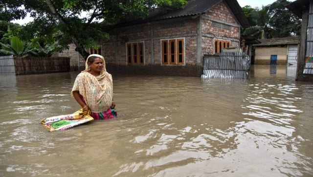
As the Monsoon trough activated across North India, heavy monsoon rains arrived in the region and provided much-needed relief from the highly sultry weather.
Delhi Safdarjung Observatory recorded 117 mm rainfall ending 8:30 am on 1 July. Strong monsoon onset resulted in heavy to very heavy rains in many parts of plains as well as hills.
Rohtak in Haryana observed 188.2 mm in the span of 12 hours, falling a little short of breaking the previous July all-time record of 193 mm from 2003.
Moderate to heavy rainfall ending 8.30 am on 1 July:
Halwara — 132.4 mm
Ludhiana — 77.0 mm
Chandigarh — 72.9 mm
Churk — 68.0 mm
Churu — 53.3 mm
Ganganagar — 47.8 mm
Bhiwani — 41.7 mm
Jaipur — 38.9 mm
Ajmer in Rajasthan recorded 134.1 mm in the last 24 hours ending 8.30 am on 2 July. It is the highest 24-hour rainfall recorded in the month of July at least in the last one decade.
The 2 July rainfall data from various stations:
Bhilwara — 79.8 mm
Chittorgarh — 79.0 mm
Pali — 68.0 mm
Narnaul — 43.0 mm
Bareilly — 15.6 mm
Ayanagar, Delhi — 14.8 mm
Meerut — 14.4 mm
Rohtak — 7.6 mm
The realised rainfall in the two hilly states of Himachal Pradesh and Uttarakhand in the last 48 hours on 1 July:
Dharamshala — 82.0 mm
Dehra Gopipur — 72.3 mm
NainaDevi — 62.2 mm
Jakholi — 58.7 mm
Berthin — 58.5 mm
Sihunta — 56.0 mm
Kangra — 43.0 mm
Palampur — 34.4 mm
Nahan — 33.0 mm
Pithoragarh — 24.9 mm
The actual rainfall in the two hilly states of Himachal Pradesh and Uttarakhand in the last 48 hours on 2 July:
Nalagarh — 65.0 mm
Shillaroo — 59.0 mm
Ukhimath — 56.5 mm
Uttarkashi — 50.0 mm
Narkanda — 43.0 mm
Song — 40.5 mm
Loharkhet — 38.0 mm
Jakholi — 37.5 mm
Solan — 30.0 mm
Kufri — 29.0 mm
Shimla — 24.3 mm
Chamoli — 19.8 mm
The monsoon rains have finally picked up across West India including Mumbai and entire Gujarat where heavy to very heavy rains have been observed in the past few days. India’s financial capital’s Santacruz Observatory recorded typical monsoonal 175mm rainfall ending 8.30 am on 1 July and another heavy rains of 105 mm till 2 July morning.
Interestingly both the National Capital and the financial capital experienced the first century i.e., above 100 mm rainfall of the season together.
The rains continue to pound North East India earlier in the week. The well-known world’s wettest region recorded the fastest ever 10,000 mm rainfall! Till 30 June Cherrapunji recorded a total annual rainfall of 10,208.4 mm which is the fastest ever since the record began.
As the monsoon is getting active in the core monsoon zone, lately the intensity and spread of rains have significantly decreased in North East India during the last two days. As per IMD data, the following is the total monsoon seasonal rains in India from 1 June till 1 July:
• India as a whole recorded a total of 162.8 mm rainfall against the average of 172.9 mm, departure from normal stands at -6 per cent.
• Southern Peninsula: Actual 148.9 mm against the average of 166.7mm, -11 per cent departure from normal.
• East and North East India: Actual 412.9 mm against the average of 342.4 mm, +21 per cent departure from normal.
• North West India: Actual 78.9 mm against the average of 82.4mm, -4 per cent departure from normal.
• Central India: Actual 129.1mm against the average of 178.9 mm, -28 per cent departure from normal.

District-wise seasonal rainfall in India so far since 1 June, 2022
All India Weather Forecast for the next week till 9 July:
Current weather synopsis in India as per Indian Meteorological Department:
• The monsoon trough passes through Bikaner, Alwar, Hardoi, Daltonganj, Shantiniketan and thence
eastwards to Northeast Bay of Bengal and extends up to 0.9 km above mean sea level.
• A cyclonic circulation lies over Bangladesh and neighbourhood and extends up to 7.6 km above mean sea level tilting southwestwards with height. Under its influence, a Low Pressure Area likely to form over north Odisha and neighbourhood during next 48 hours.
• The off-shore trough at mean sea level from south Gujarat coast to south Maharashtra coast now seen off south Gujarat-north Maharashtra coasts.
• The cyclonic circulation over East Rajasthan and neighbourhood now lies over central parts
of Rajasthan & neighbourhood between 1.5 km & 5.8 km above mean sea level.
• The trough now runs from the above cyclonic circulation over central parts of Rajasthan and
neighbourhood to West central Arabian Sea between 3.1 km and 5.8 km above mean sea level.
• A cyclonic circulation lies over northeast Madhya Pradesh and neighbourhood between 5.8 km & 7.6 km above mean sea level.
All Indian Weather Forecast for next week till 9 July:
North India:
The monsoon axis will be switching positions multiple times in the upcoming week, based on the observation rains across North India are likely to be normal to above normal throughout the next week.
Under the influence of Easterlies scattered light to moderate rains will continue in Uttar Pradesh, Punjab, Haryana, Delhi and Rajasthan till 4 July whereas parts of Himachal Pradesh and Uttarakhand may experience rather heavy rainfall in this period.
As the low pressure area from bay of Bengal will push inland the spread and intensity of rains will once again increase on 5 and 6 July when widespread heavy to very heavy rainfall may occur in Uttar Pradesh, Uttarakhand, Delhi NCR, Haryana, Chandigarh, Punjab and parts of South East Rajasthan.
Expected precipitation accumulation till 9 July:
• Uttarakhand — 140 mm
• Uttar Pradesh — 120 mm
• Delhi NCR — 90 mm
• Himachal Pradesh — 90 mm
• Haryana — 80 mm
• Rajasthan — 80 mm
• Punjab — 70 mm
Central India:
Under the influence of back of back low pressure areas from Bay of Bengal, active to vigorous Monsoon conditions are expected in Central India over the coming week.
Widespread heavy to very heavy rains are very likely in Chhattisgarh, Madhya Pradesh, Vidarbha during the period of 5 to 9 July.
Fairly widespread moderate to heavy rains are very likely in Madhya Maharashtra, Marathwada and parts of Gujarat during this period.
The rainfall over Konkan region including Mumbai will decrease slightly in the next two days but as the low-pressure area moves inland it will generate pull effect phenomenon which will once again enhance rains across coastal Gujarat and coastal Maharashtra including Mumbai and heavy to very heavy long lasting rains will return.
Expected precipitation accumulation till 9 July:
• Madhya Pradesh — 190 mm
• Maharashtra — 160 mm
• Chhattisgarh — 110 mm
• Gujarat — 80 mm
East and North East India:
As the low pressure area forms in bay of Bengal it will gather all the moisture and move westwards towards Odisha and further inland, under such situations the push of Moisture from Bay of Bengal towards North East decreases significantly resulting in below normal rains.

Weather symbols. Image courtesy Peepo/Wikimedia Commons
Over the coming week rains across Meghalaya, Mizoram, Nagaland, Tripura, Manipur, Assam, Sikkim and Arunachal Pradesh will remain mainly light to moderate in nature. The chances of extreme rains are low till 9 July.
Similarly rains are expected to decrease in sub-Himalayan West Bengal and Bihar as monsoon trough will remain south of its normal position due to low pressure area. Meanwhile a significant increase in rainfall will be observed in South West Bengal, Odisha and Jharkhand where Widespread heavy rains will be observed early next week.
Expected precipitation accumulation till 9 July:
• Odisha — 120 mm
• Jharkhand — 100 mm
• North East India — 80 mm
• West Bengal — 70 mm
• Bihar — 40 mm
South India:
As the low pressure area moves in Central parts of the country it will result in excessive moisture pulling from the Arabian sea toward the West coast of India further strengthening the off-shore trough.
Under the influence of the following Weather systems, very heavy to extremely heavy rains are expected to occur in Goa, Karnataka coastal as well as ghat section. Parts of Kerala, Andhra Pradesh and Telangana is likely to experience light to moderate rains with a few heavy spells over the coming week.
Rainfall activities may remain subdued over most parts of Tamil Nadu next week.
Expected Precipitation accumulation till 9 July:
• Goa — 350 mm
• Karnataka — 240 mm
• Kerala — 110 mm
• Telangana — 80 mm
• Andhra Pradesh — 80 mm
• Tamil Nadu — 20 mm
Monsoon conditions across the country look positive for the next one week and it will easily cover up all the deficiency of the season so far also boost the sowing of Kharif crops in the core monsoon zone.
The author, better known as the Rohtak Weatherman, interprets and explains complex weather patterns. His impact-based forecasts @navdeepdahiya55 are very popular in north India.
Read all the Latest News, Trending News, Cricket News, Bollywood News,
India News and Entertainment News here. Follow us on Facebook, Twitter and Instagram.
More News
Days Of Stone Peltinge Gone, Kashmir Now Witnesses Change Amid Elections
Guwahati Assam Lok Sabha Election 2024: Date of voting, result, candidates, main parties, schedule | India News – Times of India
Jangipur Constituency of West Bengal Lok Sabha Election 2024: Date of Voting, Result, Candidates List, Main Parties, Schedule | India News – Times of India